CNN
—
Severe storms including confirmed tornadoes have carved paths of destruction in Oklahoma and the Dallas-Fort Worth area Tuesday and injured at least seven people – part of a larger storm system that threatens more damage in the South and blizzard conditions in states farther north.
The giant winter storm system is pushing through the central US after walloping the West. About 21 million people from Texas to Mississippi are under threat of severe storms Tuesday, including tornadoes. And about 14 million people – largely in the north-central US – are under winter-weather warnings or advisories Tuesday, with blowing snow and power outages a key concern.
A tornado watch is in effect for parts of Arkansas, southeastern Oklahoma and eastern Texas until 5 p.m. CT.
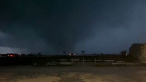
A confirmed “large and extremely dangerous tornado” was located Tuesday near Greenwood, about 7 miles west of Shreveport, according to the National Weather Service. The storm was moving northeast at 45 mph.
A tornado watch is in effect for portions of western and northern Louisiana, east Texas and southern Arkansas until 10 p.m. CST, according to the Storm Prediction Center. This watch covers more than 1.5 million people and includes Shreveport and Alexandria, Louisiana.
“Several tornadoes and a couple intense tornadoes (are) likely,” the Storm Prediction Center said. Wind gusts up to 75 mph and hail up to 1.5 inches in diameter are also possible.
Damage on Tuesday includes:
• Grapevine, Texas: At least one tornado was reported in this city just outside Dallas Tuesday morning, the National Weather Service said, and storms left at least five people there injured, Grapevine police said. Details about the injuries weren’t immediately available.
Businesses including a Grapevine mall, a Sam’s Club and a Walmart were damaged, police said. A gas station was destroyed, and drivers on one road were forced to share a single lane because downed trees and other debris blocked parts of the thoroughfare, motorist Claudio Ropain David told CNN.
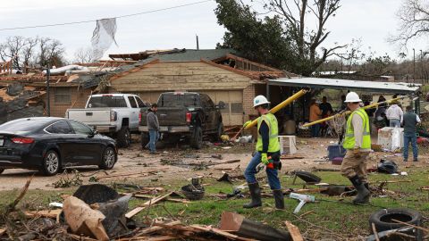
• Elsewhere outside Dallas: At least two people were injured, and homes and businesses were damaged, as severe weather hit east of Paradise and south of Decatur in Wise County on Tuesday morning, northwest of Fort Worth, county officials said.
One person was hurt when wind overturned their vehicle, and the other – also in a vehicle – was hurt by flying debris, the Wise County emergency management office said. One was taken to a hospital, the office said without elaborating.

High winds also damaged homes and trees near Callisburg north of Dallas, blew over tractor-trailers near the towns of Millsap and Weatherford; and damaged barns near the town of Jacksboro, the National Weather Service said.
• Wayne, Oklahoma: A confirmed EF2 tornado in that town knocked out power and damaged homes, outbuildings and barns early Tuesday, officials said, adding no injuries were reported. Homes were flattened or had roofs torn off, and trees were snapped like twigs, video from CNN affiliate KOCO showed.
The storm that rocked Wayne was on the ground for at least 3 miles with 120-125 mph winds, the National Weather Service in Norman, Oklahoma, said.
More severe storms capable of tornadoes, as well as hail and damaging winds are expected Tuesday and Wednesday in the Gulf Coast region as the complex snow-or-rain system sweeps through the central US from north to south.

Across the central and northern Plains and Upper Midwest, heavy, blowing snow and/or freezing rain into Thursday could snarl travel and threaten power outages.
Blizzard warnings – forecasting at least three hours of sustained winds or frequent gusts at 35 mph or greater during considerable snowfall and poor visibility – extended Tuesday from parts of Montana and Wyoming into northeastern Colorado, western Nebraska and South Dakota.
Blizzard conditions were being reported in the morning and early afternoon near the Colorado-Kansas state line. Visibility along Interstate 70 in that area was down to 100 feet, a Kansas Highway Patrol spokesman said on Twitter.
Snowfall through Wednesday morning generally could be 10 to 18 inches in the central and northern Plains and Upper Midwest. Some areas inside the blizzard warning zones – particularly western South Dakota, eastern Wyoming and northwestern Nebraska – could get as many as 24 inches of snow, with winds strong enough to knock down tree limbs and cause power outages, the Weather Prediction Center said.
Parts of Wyoming have reported snow accumulations between 1 and 2 feet, according to the National Weather Service. The state’s Department of Transportation on Tuesday said wintry weather is impacting roadways throughout the entire state.
“Not a single green stretch of road in the state,” the department said in a Facebook post. “Strong winds, blowing snow, whiteout conditions and slick spots are impacting routes statewide (and in some neighboring states!)”
The Wyoming Highway Patrol also advised motorists to be aware of road conditions, as “many roads across Wyoming are currently closed due to crashes and winter conditions.”
In Sidney, Nebraska, winds whipped Tuesday morning at 53 mph, CNN meteorologist Chad Myers said, “and then you add in the snow, visibility is a quarter mile.”
Interstates in South Dakota could become impassable amid the blizzard conditions, resulting in roadway closures across the state, the South Dakota Department of Transportation warned Monday.
Ice storm warnings were issued for parts of eastern South Dakota. Up to two-tenths of an inch of ice could accumulate in some of these areas, forecasters said.
Wintry precipitation “will begin to spread eastward over the Upper Great Lakes late Tuesday and Wednesday and into the Northeast late Wednesday as the storm system continues eastward,” the prediction center said.
Freezing rain and sleet, meanwhile, will be possible through Wednesday in the Upper Midwest.
Meanwhile, the southern end of the storm threatens to bring more tornadoes.
An alert for enhanced risk of severe weather – level 3 of 5 – was issued Tuesday for eastern Texas and the lower Mississippi River Valley, with the main threats including powerful tornadoes, damaging winds, and large hail. Baton Rouge, Shreveport, and Lafayette, Louisiana, are part of the threatened area, as is Jackson, Mississippi.
“My main concern with the tornadoes is going to be after dark,” Myers said Tuesday. “We have very short days this time of year, so 5 or 6 o’clock, it’s going to be dark out there. Spotters aren’t as accurate when it is dark. Tornado warnings are a little bit slow; if you’re sleeping, you may not get them. So, that’s the real danger with this storm.”
A zone of slight risk – level 2 of 5 – encircled that area, stretching from eastern Texas and southern Oklahoma to southern Arkansas and much of the rest of Louisiana, including New Orleans, and central Mississippi.
Tuesday also brings a slight risk of excessive rainfall in parts of Arkansas, Louisiana and Mississippi, with 2 to 4 inches of rain and flash flooding possible, the Weather Prediction Center said.
On Wednesday, the threat for severe weather is largely focused on the Gulf Coast, with tornadoes and damaging winds possible over parts of southern Louisiana, Mississippi, southwest Alabama and the western Florida Panhandle, the Storm Prediction Center said.
