The combination of howling winds — as strong as 70 miles per hour in some areas — along with fast-accumulating snow is a recipe for blizzard conditions, particularly in the New England states.
Whiteout conditions are expected across the region, and several governors declared states of emergency as they urged residents to stay off roads. There are also warnings of coastal flooding and the possibility of power outages due to downed utility lines.
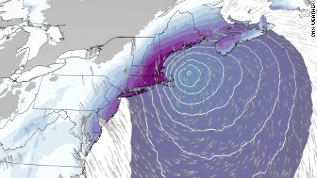
And while the path has been uncertain in the run-up to this winter storm, key points were clearer by Saturday.
Blizzard warnings issued Friday covered 10 million people across 10 states in coastal counties from New England to Virginia. Notable locations included Portland, Maine; Boston and Cape Cod, Massachusetts; the eastern half of New York’s Long Island; Atlantic City, New Jersey; and Ocean City, Maryland.
Whiteout conditions will make travel difficult to impossible, the NWS predicted. In a blizzard, snow is joined by winds gusting over 35 mph for more than three hours, creating visibility of less than a quarter of a mile.
“The strong-to-damaging winds will lead to scattered power outages,” the NWS warned.
There is “high confidence” this will be a “historic major winter storm for eastern New England,” with widespread snowfall of one to two feet, the National Weather Service said Friday evening.
Extremely cold temperatures and coastal flooding are possible, the Weather Prediction Center warned.
“Coastal flooding is a concern thanks to astronomically high tides on Saturday,” the weather service office in Boston said. “The combination of strong northeast winds and high seas will bring storm surges that, if coinciding with high tide, would lead to minor or moderate coastal flooding.”
The difference in storm timing — even as few as six hours — would make a massive difference in impact on coastal flooding and erosion concerns.
Massachusetts and Rhode Island expected to see the worst of it
Eastern Massachusetts, including Boston, will bear the brunt of the system as forecast models predict between 18 to 24 inches of snow combined with wind gusts up to 70 mph.
Two to 4 inches per hour could fall in Boston, with conditions likely to peak between 8 a.m. and 5 p.m. Saturday. Similar snow total and wind predictions are in place for Rhode Island.
Boston declared a “snow emergency” that began Friday at 9 p.m.
“This has a potential to be a historic storm, a huge one,” Boston Mayor Michelle Wu said. “This is likely to be an intense, dangerous storm, with heavy snow, high winds and whiteout conditions.”
Rhode Island Gov. Daniel McKee declared a state of emergency ahead of the storm and took precautions a step further by signing a travel ban beginning Saturday at 8 a.m. through 8 p.m. due to whiteout conditions.
Amtrak canceled train service on Saturday for various lines, including Acela service between Washington, DC, and Boston and regional service between Boston and New York, the company said Friday.

Tri-state area, Pennsylvania and Delaware
Meanwhile, the governors of New York and New Jersey also declared states of emergency.
New York City could get 8 to 12 inches of snow with 45 mph gusts, while 14 inches could pile up elsewhere in New York state as well as Connecticut, where wind gusts may be as strong as 55 mph, CNN meteorologists and the weather service predicted.
But the weather service early Friday said there is a 10% chance the storm may dump more than 17 inches of snow in New York City and also predicts a 10% chance of 4 inches of snow.

The impact in New York City will peak from 5 a.m. to 4 p.m. Saturday.
As a precaution, all Long Island Rail Road service will be suspended beginning Saturday morning, the Metropolitan Transportation Authority said.
Across the Hudson River, northeast New Jersey could see 7 to 10 inches of snow, with winds gusting up to 45 mph.
And the Philadelphia area in eastern Pennsylvania is also expected to get 4 to 11 inches of snow.
Maryland, Virginia and North Carolina

Between 8 and 12 inches of snow could pile up in parts of southeast Maryland and eastern and southeast Virginia, where winds are expected to gust as high as 50 mph.
