Mother Nature will provide her own version of fireworks in the form of thunder and lightning, but it will be in addition to flooding, strong winds, and even possible tornadoes.
As we end one year and start another, severe storms will mark both occasions, as a cold front pushes its way into the springlike warmth that has been in place all week over the southern states.
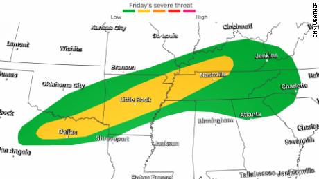
Friday, the greatest areas at risk will be from Dallas, Texas, to Lexington, Kentucky. These storms will be capable of all severe weather hazards including large hail, damaging winds, flooding, frequent lightning, and a few tornadoes.
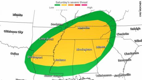
By Saturday, the threat for severe storms shifts farther east and south, but also expands to impact even more locations.
Flooding will also be a major concern, especially across Kentucky where cleanup is still ongoing from the tornadoes that ripped through the area nearly three weeks ago.
Widespread rain totals of 1-3 inches are expected from western Arkansas to western Pennsylvania. Kentucky could see the highest amounts, up to 4 inches through the weekend.
Given the ground is already saturated across Arkansas, Kentucky, and Tennessee, flooding and flash flooding are very possible.
New year, new (colder) weather
This could be the first significant snow event of the season for the Midwest, with widespread snowfall accumulations of 4 inches possible from eastern Kansas to Lake Michigan. Heavier snow bands could result in even higher amounts of 6-8 inches or more along the Iowa/Missouri border and northern Illinois, resulting in widespread travel disruptions.
Heavy snow is also expected Friday night into Saturday morning for Colorado, Wyoming, and New Mexico where snow will range from 3-5 inches in the lower elevations all the way up to 1-3 feet for the highest elevations of the Rocky Mountains.
You can’t have snow without cold, and there will be a major drop in temperatures this weekend.
On Friday, Indianapolis goes from highs around 60 degrees all the way down to highs in the low 20s on Sunday, with some snow showers mixed in.
The Dallas-Fort Worth area, which has set numerous record high temperatures the past two weeks, will have high temperatures on Saturday near 70 degrees down to highs in the low 40s on Sunday.
Did you say cold? Why not play some hockey? The Winter Classic outdoor game that is traditionally played on New Year’s Day will be in Minneapolis this year, and it’s going to be a cold one. The high temperature on Saturday is only supposed to reach -2 degrees, but it will be even colder when the game begins at 6 p.m. CST with a downright frozen temperature of -5 with a wind chill hovering around -20 degrees.
