CNN
—
An atmospheric river event, bringing ample amounts of moisture to the West this weekend, will gradually move across the country and bring hazardous weather to millions.
The blockbuster storm will begin in the West with heavy snow, gusty winds, and coastal flooding, then move eastward, threatening potential blizzard conditions in the Midwest and tornadoes in the South.
More than a half dozen western states are under winter weather alerts this weekend as the potent storm system moves across the region.
Snow will be measured in feet across the Sierras, Rockies, and Cascades. Heavy rain will also be notable up and down the West Coast, particularly in California, where flooding concerns exist through Sunday.
An atmospheric river is a plume of moisture which streams in off the Pacific Ocean. Similar to a fire hose, it shoots moisture into one area for an extended period of time, resulting in very heavy rain or snow.
Most coastal communities will pick up 1 to 3 inches of rain through the weekend, and some areas of northern and central California could receive 3 to 5 inches of rain in total. Coastal erosion and flooded roadways will be the main concerns.
“Additional heavy rains may result in isolated runoff issues, especially across recent burn scars,” the Weather Prediction Center said.
Winds will also be a concern for California, with gusts of up to 40 mph in the valleys, 50 mph for coastal areas, and potentially even higher gusts forecast for exposed coastal headlands, mountaintops, and ridges.
And the western US will not be the only area affected by the storm.
“As the system moves into the Plains early next week, a springlike storm system develops,” Chad Myers, CNN Meteorologist said. “Significant severe weather will occur in the warm air across the South and a major snow and ice event will happen in the western Great Lakes and northern Plains.”
For the northern Plains and Midwest, the threat for blizzard conditions is increasing, as significant snow, strong winds, ice and freezing rain will all be possible early next week from Colorado through Wisconsin.
“A winter storm is expected to impact the Northern Plains Monday night through Thursday,” the National Weather Service office in Bismarck, North Dakota said. “Difficult travel conditions are expected Monday night through Wednesday night from heavy snow, reduced visibility, and drifting snow.”
Heavy snow and strong winds will be the main concerns, but freezing rain and ice are also possible.
If winds are at least 35 mph and visibility is less than one quarter of a mile for at least three hours, it could result in a full-blown blizzard across the region.
Widespread snow accumulations across the northern Plains and Midwest will be 4 to 8 inches, and some locations could pick up in excess of one foot through Friday of next week.
“While some uncertainty persists, confidence is increasing that strong winds and significant snows will produce hazardous impacts across much of the Central/Northern Plains and into the Upper Midwest,” the prediction center said.
Slick roadways and near-whiteout conditions will make travel very difficult if not impossible at times for some of these areas. Power outages will also be possible due to very strong winds.
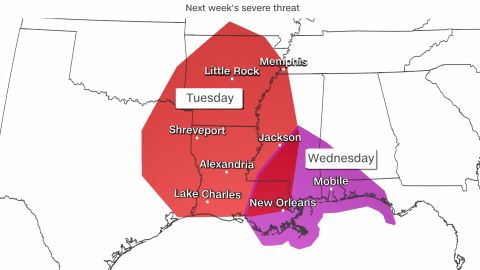
The threat for severe storms is also increasing across the southern Plains and Gulf Coast region including tornadoes, large hail, and damaging winds.
“While tornadoes in December are relatively uncommon when compared to the springtime, they are often more likely across portions of the Southeast and Lower Mississippi Valley, where there is often a secondary peak in the fall and winter,” Matthew Elliott, a meteorologist at the Storm Prediction Center, told CNN.

The severe storm potential begins Monday night across Oklahoma and northern Texas, gradually spreading into Arkansas, Louisiana, and Mississippi on Tuesday.
Severe storms will likely continue Tuesday overnight across the Gulf Coast region. Nocturnal tornadoes are more dangerous because many people are asleep and unaware they need to be seeking a safe location.
While the greater tornado threat exists during the day, there is still the possibility for a few rotating storms through the evening hours.
By Wednesday, the greatest threat exists for an area from New Orleans to Panama City, Florida.
“The details regarding the areas most at risk from tornadoes will become clearer as the event approaches and smaller-scale trends become more evident,” Elliott said.
Because the forecast can change it is important to pay attention to developments in the coming days.