Strong storms with heavy winds and rain are possible Friday night across the Treasure Coast and Palm Beach County.An increase in tropical moisture is bringing storms further inland and increasing humidity across South Florida. The heat index will be around 100 degrees.Weather | Radar | Hurricanes | Traffic | uLocal | Facebook | Twitter | InstagramSlow-moving storms could cause localized flooding in areas near the coast – with some areas seeing the potential for 1 to 3 inches of rain. The main time frame for the thunderstorms is 1 p.m. to 9 p.m.The same pattern is expected on Saturday.This comes as most of the Treasure Coast and Palm Beach County are facing a drought during the peak part of the rainy season. As of last week, 16.5% of the state was included under the “abnormally dry” category.Share with us: Upload your weather photos and videos via uLocalStay updated on the latest weather updates with the WPBF 25 News app. You can download it here.
Strong storms with heavy winds and rain are possible Friday night across the Treasure Coast and Palm Beach County.
An increase in tropical moisture is bringing storms further inland and increasing humidity across South Florida. The heat index will be around 100 degrees.
Weather | Radar | Hurricanes | Traffic | uLocal | Facebook | Twitter | Instagram
Slow-moving storms could cause localized flooding in areas near the coast – with some areas seeing the potential for 1 to 3 inches of rain.
The main time frame for the thunderstorms is 1 p.m. to 9 p.m.
The same pattern is expected on Saturday.
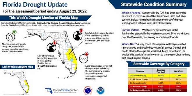
This comes as most of the Treasure Coast and Palm Beach County are facing a drought during the peak part of the rainy season. As of last week, 16.5% of the state was included under the “abnormally dry” category.
Share with us: Upload your weather photos and videos via uLocal
Stay updated on the latest weather updates with the WPBF 25 News app. You can download it here.
