NEWYou can now listen to Fox News articles!
National Weather Service Director Ken Graham called Hurricane Ian a “historic event” that will be talked about “for many years to come” Wednesday.
“I wish this wasn’t a forecast I had to deliver,” Graham said. “I wish this wasn’t a forecast that’s about to come true. This is a devastating storm for parts of Florida, not just on the southwest coast, but also inland associated with some of these impacts.”
“This is going to be a storm we talk about for many years to come,” Graham said.
“Historic event,” he added.
The Federal Emergency Management Agency and the American Red Cross stressed that they have pre-positioned resources to respond to the Category 4 storm, whose dangerous eyewall is moving onshore in Florida’s west cost.
This satellite image provided by NASA on Sept. 26, 2022, shows Hurricane Ian pictured from the International Space Station just south of Cuba gaining strength and heading toward Florida.
(NASA via AP)
With historic winds and a rapid approach towards the Sunshine State, the National Weather Service is utilizing weather balloons and radar to stay as up-to-date as possible.
“I literally have my phone up here because things keep changing as we speak with a storm like this. It’s very common, so I’ll be able to bring you the latest information,” Graham said.

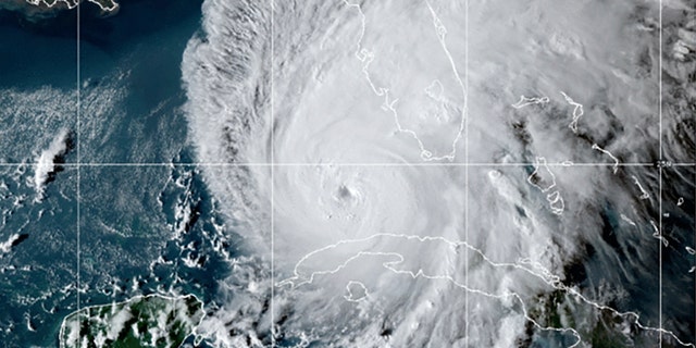
This GOES-East GeoCcolor satellite image taken at 10:10 p.m. EDT on Tuesday, Sept. 27, 2022, and provided by the National Oceanic and Atmospheric Administration, shows Hurricane Ian over the Gulf of Mexico.
(NOAA via AP)
CLICK HERE TO GET THE FOX NEWS APP
Gov. Ron DeSantis told Floridians in the path of Ian that the time has passed to evacuate and residents should now “hunker down.”
Ian is expected to make landfall in Charlotte County Wednesday as a Category 4 storm, with the highest risk areas ranging from Collier County to Sarasota County.
“If you are in any of those counties, it’s no longer possible to safely evacuate. It’s time to hunker down and prepare for this storm,” he urged.