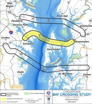
The decade-long process to finalize the location of the third span of the Chesapeake Bay Bridge is over, with the site chosen to be within 2 miles of the current Bay Bridge.
The study’s decision, released Thursday, comes after the Maryland Transportation Authority announcement Aug. 27, 2019, that 14 proposed locations were now down to three.
Here’s what you need to know about the proposed third span of the Chesapeake Bay Bridge.
Why is a Bay Bridge third span so important?
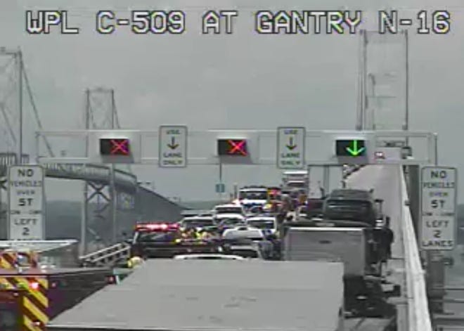
Mounting infrastructure concerns and spot repairs have led to a crescendo of support for the new span, namely from Gov. Larry Hogan, as traffic is only expected to increase on the outdated bridge.
While some Eastern Shore residents have decried the amount of potential additional traffic, especially through residential areas while using apps like Google Maps, others welcome the boon for tourist-dependent locations like Ocean City and Rehoboth Beach.
The need for a third span, the transportation authority also explains, is clear when currently the summer weekend traffic on the bridge is more than 118,600 vehicles. Non-summer weekends dip to more than 68,000 vehicles.
By 2040, those totals are expected to balloon to 135,300 vehicles on summer weekends and 84,300 vehicles on non-summer weekends.
Will this bring traffic relief?

The selected location runs along the existing Bay Bridge corridor on Route 50/301 to Route 50 between Crofton and Queenstown.
“Additional capacity in the selected corridor would divert substantially more traffic away from the Bay Bridge lanes in terms of total vehicles per day on both summer weekends and non-summer weekdays,” the report stated.
The other two potential options included Corridor 6 (on Route 100 to Route 301 between Pasadena and Centreville) and Corridor 8 (on Route 50/301 between Crofton and Easton).
YOUR DRIVE:What happens if Chesapeake Bay Bridge doesn’t add another crossing
In comparison, the report stipulates, additional capacity in the selected corridor would result in greater peak-hour congestion relief on the Bay Bridge lanes.
Other findings include the rejected locations would also likely cause substantially “more indirect effects from new connectivity between rural lands on the Eastern Shore and employment centers” such as Baltimore and Washington, D.C.
They could also lead to substantial pressure for new residential development, with corresponding negative impacts to farmland.
How will this impact the Chesapeake Bay environment?

The location decision comes on the heels of the combined Final Environmental Impact Statement and Record of Decision being released to the public.
According to the final Tier 1 report, one of the considerations in moving forward with the selected location was the overall length of a proposed span.
The selected route would potentially “have lower overall environmental impacts” due to the shorter length of the crossing the report noted.
The two rejected locations would have required longer crossings and more roadway infrastructure, likely resulting in greater impact to sensitive environmental resources in and around the Chesapeake Bay.
CHESAPEAKE BAY:Dolphins’ playful social habits could also be what’s killing them, researchers say
SEAFOOD:Maryland shrimp? Warming waters could bring seafood bonanza to Eastern Shore
Some minimal impact was identified to affect open water of the bay and other major waterways. Yet in comparison, aquatic resources associated with open water — such as essential fish habitat, tidal wetlands, and oyster resources — are more prevalent in Pasadena to Centreville option or Crofton to Easton option.
Proposed, and ultimately rejected, options further north and south would have been longer routes with more invasive impacts on the bay and Eastern Shore farmland.
The chosen location also presents less impact to existing communities’ cohesion and local traffic.
“Much of the land adjacent to the existing US 50/301 roadway is developed, so utilizing this infrastructure potentially minimizes overall impacts to on-land natural resources,” the report stated.
What’s next toward building the span?
The next phase is for the selected location to undergo a Tier 2 study, with a completion date not yet released.
Under Tier 2 regulations, coordination with the U.S. Fish and Wildlife Service would be required for any potential effects on listed endangered or threatened species in accordance with the Endangered Species Act.
The Chesapeake Bay Oyster Alliance, the Maryland Department of Natural Resources, the Virginia Marine Resources Commission, and the National Oceanic and Atmospheric Administration, among others, may also be required to evaluate potential aquatic resource impacts.
CARGO SHIP:Finally free! Container ship Ever Forward stuck in Chesapeake Bay gets moving again
A timeline for the Tier 2 study has yet to be announced as it is expected to cost around $30 million, according to The Baltimore Sun.
The required National Environmental Policy Act study will examine specific alignment alternatives within the 2-mile wide selected range as well as more specific environmental affects.
As part of the effort by both the Federal Highway Administration and the Maryland Transportation Authority, the public is able to view the full report and all its associated graphs at libraries.
They include:
- Easton Main Library at 100 W Dover St., Easton.
- St. Michaels Library at 106 Fremont St., St. Michaels.