CNN
—
Much of California can’t soak up another drop of rain. Yet the state is getting pummeled again with torrential downpours and ferocious winds, causing power outages and treacherous travel conditions.
More than 34 million Californians are under a flood watch Monday – about 90% of the state’s population and 10% of the US population.
Parts of the central California coast got walloped with 1 to 1.25 inches of rainfall per hour, the Weather Prediction Center said. Monday’s rapid deluge also led to reports of mudslides and rockfalls in the Diablo Range.
And hurricane-force wind gusts topping 74 mph thrashed states across the western US. More than 37 million people are under wind alerts Monday in California, Nevada, Oregon, Washington, Utah, Arizona and Wyoming.
A 132-mph wind gust lashed Oroville, California. Residents in Washoe City, Nevada, were hit with a 98-mph gust, the Weather Prediction Center said.
“Expect widespread power outages, downed trees and difficult driving conditions,” the National Weather Service in Sacramento tweeted. “Now is the time to prepare if you have not already!”
Already, more than 138,000 homes, businesses and other power customers had no electricity Monday, according to PowerOutage.us.
And the central California coast could be at risk of a tornado, CNN Meteorologist Dave Hennen said.
The severe weather is part of a relentless parade of atmospheric rivers slamming the West Coast.
California is now extremely vulnerable to flooding because much of the state has been scarred by historic drought or devastating wildfires – meaning the land can’t soak up much rainfall.
And after an onslaught of storms since late December led to deadly flooding, Gov. Gavin Newsom warned Sunday: “We expect to see the worst of it still in front of us.”
Two bouts of major rainfall are expected to hammer the West Coast over the next few days – without much of a break between events for the water to recede.
The system is part of an atmospheric river – a long, narrow region in the atmosphere that can transport moisture thousands of miles, like a fire hose in the sky.
The atmospheric river slamming California on Monday could result in a 1-in-50 year or 1-in-100 year rainfall event near Fresno, the Weather Prediction Center said.
A moderate risk – level 3 of 4 – of excessive rainfall covers over 26 million people in California, including in San Francisco, Sacramento, Los Angeles and Fresno, where rain could fall at 1 inch per hour.
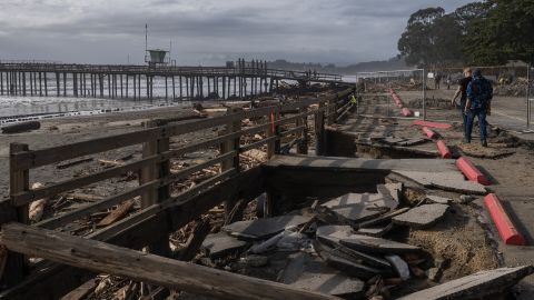
The San Lorenzo River in Santa Cruz County has risen 14 feet in just over four hours and is in major flood stage. Parts of the county will experience “widespread flooding at shallow depths,” and the city of Santa Cruz will have serious flooding, according to data from the National Oceanic and Atmospheric Administration and US Geological Survey.
The threat will shift further south Tuesday, with a level 3 of 4 risk centered over Los Angeles.
“While some of the forecast rain totals are impressive alone, it is important to note that what really sets this event apart are the antecedent conditions,” the National Weather Service office in San Francisco said.
“Multiple systems over the past week have saturated soil, increased flow in rivers and streams, and truly set the stage for this to become a high impact event.”
In Sacramento County, officials warned “flooding is imminent” and issued evacuation orders for the Wilton community near the Cosumnes River before roads become impassable.
Wilton residents also had to evacuate during last week’s storm, when exit routes flooded quickly, officials said.
El Dorado, Monterey, Santa Cruz and Santa Clara and Alameda counties have issued evacuation warnings or recommendations for some areas due to possible flooding and other safety risks as forecasters warned of swelling rivers.

Newsom on Sunday asked the White House for an emergency declaration to support response and recovery efforts.
“We are in the middle of a deadly barrage of winter storms – and California is using every resource at its disposal to protect lives and limit damage,” Newsom said in a statement. “We are taking the threat from these storms seriously, and want to make sure that Californians stay vigilant as more storms head our way.”
This storm system arrives on the heels of a powerful cyclone that flooded roads, toppled trees and knocked out power last week to much of California. Earlier, a New Year’s weekend storm system produced deadly flooding.
At least 12 Californians have died from “storm-related impacts” such as flooding since late December, the governor’s office said.
“Floods kill more individuals than any other natural disaster,” California Emergency Services Director Nancy Ward said Sunday. “We’ve already had more deaths in this flood storm since December 31 than we had in the last two fire seasons of the highest fire acreage burned in California.”
Flood-related deaths can happen when drivers attempt to cross standing water.
“Just a foot of water and your car’s floating. Half a foot of water, you’re off your feet. Half foot of water, you’re losing control of your vehicle,” Newsom said.
“We’re seeing people go around these detours because they don’t see any obstacles – they think everything is fine, and putting their lives at risk or putting first responders lives at risk.”
For anyone who doesn’t need to travel during the peak of this storm, “please don’t,” California Secretary of Natural Resources Wade Crowfoot said. “Be prepared for power outages and other interruptions. Have those flashlights, the candles, batteries, charge cell phones at the ready.”
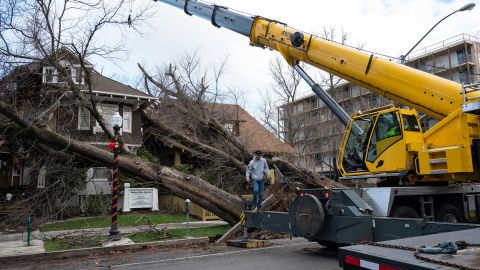
Already, flooded roads, toppled trees and downed power lines are making travel difficult, California Highway Patrol said. Some fallen trees crushed cars and homes over the weekend.

California is experiencing “weather whiplash,” going from intense drought conditions to now contending with its fifth atmospheric river, Newsom said.
Much of the state has already seen 5 to 8 inches of rain over the last week. Two to 4 more inches of rain are expected across the coasts and valleys – and even more in mountains and foothills through Tuesday.
Rising from swelling rivers could spill over and inundate communities.
The rainfall over the weekend brought renewed flood concerns for streams, creeks and rivers. The Colgan Creek, Berryessa Creek, Mark West Creek, Green Valley Creek and the Cosumnes River all have gauges that are either above flood stage or expected to be in the next few days.
“The cumulative effect of successive heavy rainfall events will lead to additional instances of flooding. This includes rapid water rises, mudslides, and the potential for major river flooding,” the National Weather Service said Monday.
The moisture is expected to sink southward Monday night, making flooding “increasing likely” over the Southern California coastal ranges Tuesday, the weather service said. Fierce winds are expected to accompany the storm as it pushes inland.
“Valley areas will likely see gusts as high as 45-50 mph, with gusts greater than 60 mph possible in wind prone areas,” the National Weather Service in Reno said. The Sierra Ridge could receive peak gusts between 130 to 150 mph Monday.
For those at higher elevations, intense snow and ferocious winds will be the biggest concerns.
Parts of the higher elevations in the Sierra Nevada have gotten more than 100” – or 8.3 feet – of snow in just the past few weeks, the Weather Prediction Center said.
Now, another 6 feet of snow is expected in some parts of the Sierra.
As the storm pushes inland, more than 5 feet of snow could fall along the Sierra Crest west of Lake Tahoe, the weather service said.
The heavy snow and strong winds could lead to near whiteout conditions on roads.